
Croaghan Hill [Cruachan]
Good walks are even better shared.
Overview
Croaghan Hill [Cruachan]
Nestled in County Leitrim, Croaghan Hill is not just another bump on the map; it stands tall at 349 meters, offering hikers stunning vistas and a dash of Irish charm. Its prominence may not make it the highest peak on the island, but the views from its summit sure are a sight to behold!
Geology
Primarily composed of sandstone, the hill showcases classic upland features with steep rock faces that have been sculpted through millennia of weathering. Keep your eyes peeled for fascinating outcrops as you ascend!
Routes
The Croaghan Hill Loop is a spectacular way to experience this landscape. Departing from the village of Dromahair, the route is approximately 8.5 km long, taking about 3.5 hours to complete at a moderate pace. Be ready for a mix of rocky paths and boggy sections that remind you of just how real an Irish hike can feel!
Summit Features
Reaching the summit, you're greeted by a well-built cairn, and there's plenty of space to take in the panoramic views. Nothing like a good hike to recharge the batteries!
Terrain Type
Expect a delightful mix of grassy slopes with rocky outcrops, alongside boggy patches that can test your wellies! Perfect for muddy adventures!
Views
From the top, you can gaze upon the shimmering waters of Lough Gill and the rugged Sligo Mountains. The views are best in late spring to early autumn, especially when the heather adorns the landscape.
Hazards
While the climb is rewarding, do be cautious of sudden weather changes and those pesky uneven paths. Good footwear and an umbrella (Irish style!) are highly recommended.
Nearby Summits
If you're feeling up for a challenge, nearby peaks like Knocknarea and Benbulben are calling your name. Just be sure to bring enough sandwiches for the journey!
Access
You can park comfortably in Dromahair, where the trailhead begins. Buses are available, but do plan accordingly, as they might not run as frequently as you’d hope on a lazy Sunday.
Facilities
The village boasts a couple of quaint cafes and shops for snacks and supplies. Make a pit stop for a cuppa before you head up!
History
The name 'Croaghan' comes from 'Cruachán', or 'little stack', a nod to its height. Historically significant, this area has roots in the ancient kingdom of Breifne, painting a rich tapestry of Ireland's past right into your hiking experience.
So pack your bags, lace up those hiking boots, and let’s make some memories at Croaghan Hill – where the scenery is fab, and the only thing missing is you!
Explore routes near Croaghan Hill [Cruachan]
Public walks starting within 80 km of this hill. Nearby does not mean a route reaches the summit; check its map and access before setting out.
Derry~Londonderry City Walls Circuit
View route
Banagher Glen and Forest: complete higher-return circuit
View route
Florence Court: Riverside and Forest Circuit, County Fermanagh
View route
Peatlands Park Red Trail: Annagarriff Wood and Derryadd Lough
View route
Route planning notes
These notes describe possible approaches, not verified navigable routes or permission to cross land. Check current paths, local access rules and conditions before setting out.
Croaghan Hill Loop
Starting from the village of Dromahair, this loop encompasses a blend of boggy and rocky terrains, allowing for a genuine Irish hiking experience.
Make a day of it, together
Find someone to share the walk with, or organise a day out along a route you like.
Hill facts and local notes
Classifications
Elevation
217m
712 ft
Prominence
171m
Coordinates
54.8235, -7.5356
H299974
OS Map
06 12
At the Summit
The summit is marked by a prominent cairn and offers panoramic views of the surrounding landscape, making it a great spot for a well-deserved rest or a selfie.
Terrain & Geology
Primarily composed of sandstone, Croaghan Hill showcases classic upland features, including steep rock faces and sheltered glades, a true testament to the forces of nature that shaped it over millions of years.
Views & Scenery
Dramatic views of Lough Gill and the surrounding Sligo Mountains, with breathtaking vistas that reveal themselves at the top.
History & Heritage
Name Origin
The name 'Croaghan' is derived from the Irish 'Cruachán', meaning 'little stack', referencing its conical shape.
Historical Significance
Historically, the area was significant for its rich agricultural lands and was part of the ancient kingdom of Breifne.
Getting There & Facilities
Check current local access restrictions, parking rules and transport timetables before travelling. These notes do not confirm public access to the summit.
Parking
There is designated parking available at the trailhead in Dromahair, with enough spaces for several vehicles, though it might fill up on sunny weekends.
Public Transport
Local buses operate to Dromahair from nearby towns, but check schedules ahead of time, as they can be sparse on weekends.
Nearby Facilities
The village of Dromahair has a couple of cafes and convenience stores for supplies. Public toilets are available near the village square.
Safety Information
Known Hazards
- Watch out for sudden weather changes typical in the Irish hills, as well as uneven terrain that can present challenges, especially in wet conditions.
General Safety Tips
- Check weather conditions before setting out
- Carry appropriate clothing and equipment
- Let someone know your planned route
- Take a map, compass, and GPS device
- Carry emergency supplies: food, water, first aid kit, torch
Hills
Some common questions about the hills answered
Are there group walks up Croaghan Hill [Cruachan]?
Many walkers use Walkmates to join or organise walks with others. You can check for group walks around Croaghan Hill [Cruachan] through the maps
Are there other walkers around Croaghan Hill [Cruachan]?
Activity varies by location and time, but Walkmates lets you see whether others have shared walks or shown interest in this area. Find other people through the walking friends search walking friends for Croaghan Hill [Cruachan] search or of course create your own walk for Croaghan Hill [Cruachan]
Can I organise a walk to Croaghan Hill [Cruachan]?
Yes. If there aren’t any walks listed already, you can create a walk and make it available for others to join.
If you're signed up to Walkmates, you can create a walk to Croaghan Hill [Cruachan].
How do I find a walk up this hill?
There are often multiple ways to walk this hill, depending on experience and route preference. Walkmates helps you explore walks and routes that others have shared.
Can I suggest a new route up Croaghan Hill [Cruachan]?
Yes. You can suggest or create routes to share with others. Walkmates focuses on the social side of walking, so routes are used to help people organise walks and explore areas together, rather than as detailed navigation tools or route libraries.
Other uses really appreciate knowledgeable walkers sharing their routes. Share your favourite route to Croaghan Hill [Cruachan] here
The is an error or something incorrect about this hill. How do I let you know?
We always strive to keep the information on Walkmates as accurate as possible. If you find an error, please let us know through the contact form and we'll aim to correct it as quickly as possible
Community Discussion
Comments
Location
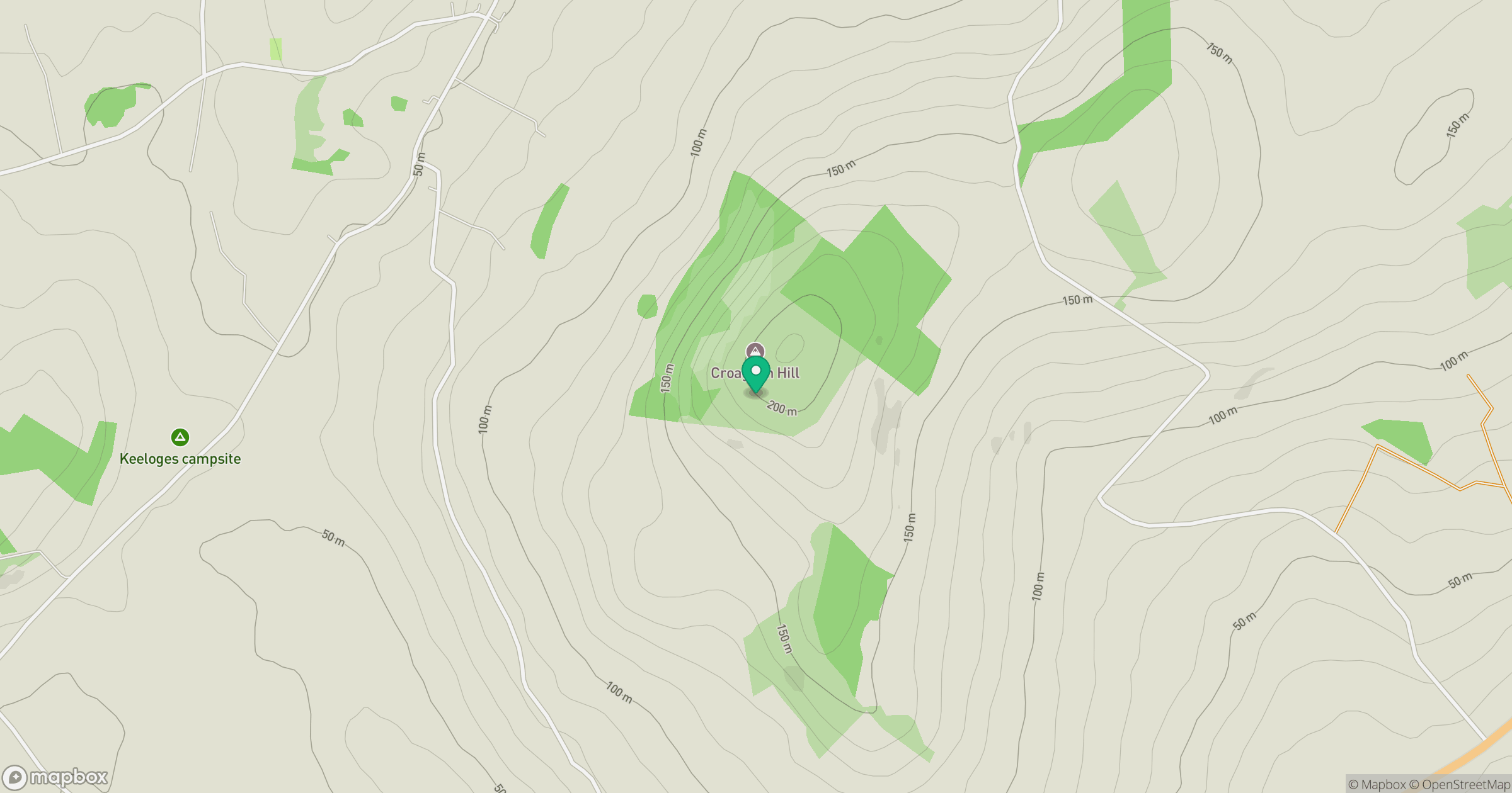
Grid reference: H299974
View on OpenStreetMapOpens a map in a new tab, centred on the hill.
Hills within 30 km
Straight-line distance, not a walking route or confirmation of access.
Binnion Hill
190m
Mongorry Hill [Cnoc Mhoin Ghofraidh]
284m
Dooish Mountain [An Dubhais]
266m
Mullaghcroy [Forster's Mountain] [Mullach Crua]
242m
Owenreagh Hill
407m
No comments yet. Be the first.